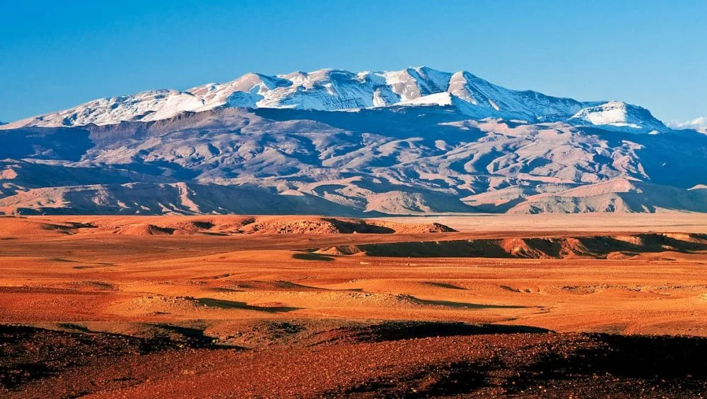
The Atlas Mountains form one of the most influential physical features in North Africa, stretching across Morocco, Algeria, and Tunisia. Any serious geographical interpretation of the region begins with a careful reading of relief patterns, elevation gradients, and ecological transitions, many of which become immediately clear when examining a map of the Atlas Mountains in Africa.
This mountain system does not merely occupy space; it actively shapes climate, water systems, settlement patterns, and even historical trade routes across the Maghreb.
Understanding the Atlas Mountains through mapping allows us to see how a single geological structure can influence vast regions in interconnected ways. From coastal humidity barriers to desert boundary formation, the mountains act as both divider and connector in North Africa’s environmental and human systems.
Geographic Structure and Regional Division
The Atlas Mountains are not a single continuous ridge but a complex system composed of several subranges: the High Atlas, Middle Atlas, Anti-Atlas, Tell Atlas, and Saharan Atlas. When viewed on a map of the atlas mountains in africa, this fragmentation becomes clear, revealing a layered structure that runs diagonally across the northwestern corner of the continent.
The High Atlas in Morocco contains the highest peaks, including Mount Toubkal, which rises above 4,100 meters. To the east, the range gradually transitions into lower elevations, merging into semi-arid plateaus and desert margins. The Anti-Atlas, in particular, marks an older geological formation, heavily eroded but still significant in shaping southern Morocco’s topography.
A map of the Atlas Mountains in Africa highlights how these subranges form a natural spine separating the Mediterranean-influenced north from the Saharan interior. This division is not just physical—it has profound ecological and cultural consequences that continue to define regional differences today.
Climatic Influence and Rainfall Distribution
One of the most important roles of the Atlas Mountains is their impact on climate. Acting as a barrier between the Atlantic and Mediterranean air masses and the Sahara Desert, the mountains create sharp rainfall contrasts. Northern slopes receive significantly more precipitation, while southern regions lie in rain shadows, contributing to arid conditions.
When studying a map of the atlas mountains in africa, one can observe how elevation aligns with rainfall distribution. Moist air from the Atlantic is forced upward along mountain slopes, cooling and condensing into precipitation. This orographic effect supports forests, agriculture, and seasonal rivers in otherwise semi-arid regions.
The climatic boundary created by the Atlas Mountains effectively determines where Mediterranean ecosystems end and desert ecosystems begin. Without this barrier, the Sahara’s influence would likely extend much further north, dramatically altering the environmental balance of the region.
Hydrology and Water Systems
Water availability in North Africa is heavily dependent on the Atlas Mountains. Snowfall in higher elevations, especially in the High Atlas, provides a crucial seasonal water source. As snow melts, it feeds rivers and underground aquifers that support agriculture and urban settlements downstream.
A map of the atlas mountains in africa clearly shows the radial drainage systems originating in the mountain ranges. Rivers such as the Oum Er-Rbia and the Moulouya in Morocco depend on this mountain runoff. These water systems are essential for irrigation, especially in regions that would otherwise be too dry for sustained farming.
The mountains also contribute to the formation of fertile valleys and basins. Over time, erosion from rainfall and melting snow has carved out productive agricultural corridors that support dense human populations compared to surrounding desert areas.
Human Settlement and Historical Trade Routes
Human settlement patterns in North Africa have long been influenced by the Atlas Mountains. Berber communities, in particular, have historically inhabited mountain valleys, taking advantage of natural protection, water access, and arable land.
Examining a map of the atlas mountains in africa reveals how settlements cluster along valleys and foothills rather than high ridges or desert plains. These geographic constraints shaped not only where people lived but also how they moved and interacted.
The Atlas Mountains also played a key role in trans-Saharan trade networks. Caravan routes often passed through mountain passes that connected the Mediterranean coast with sub-Saharan Africa. These routes facilitated the exchange of gold, salt, textiles, and cultural ideas, making the Atlas region a crucial link between different civilizations.
Biodiversity and Ecological Zones
The ecological diversity of the Atlas Mountains is remarkable, given their location near the Sahara Desert. Elevation changes create distinct ecological zones, ranging from Mediterranean forests to alpine meadows and semi-arid scrublands.
The Atlas Mountains in Africa help illustrate these vertical ecological transitions. In lower elevations, cork oak and pine forests dominate, while higher elevations support juniper and cedar species. The famous Atlas cedar is endemic to this region and represents one of its most ecologically significant species.
Wildlife such as Barbary macaques, wild boars, and various bird species depend on these habitats. The mountains serve as a biodiversity refuge, preserving species that would otherwise struggle to survive in surrounding desert environments.
Economic and Cultural Importance
Beyond environmental functions, the Atlas Mountains have significant economic and cultural roles. Agriculture remains a primary livelihood, with terraced farming systems adapted to steep slopes. Crops such as barley, olives, and citrus fruits are common in mountain valleys.
Mining also plays a role in some regions, where mineral deposits are extracted from ancient geological formations. Additionally, tourism has grown in importance, with hikers and climbers attracted to scenic peaks and traditional villages.
A Mountains in Africa also reveals how cultural diversity aligns with geography. Many indigenous Amazigh (Berber) communities maintain distinct languages, traditions, and architectural styles adapted to mountainous living conditions. These cultural landscapes are tightly interwoven with the physical environment.
Conclusion
The Atlas Mountains are far more than a geographical feature; they are a defining force in North African environmental and human systems. From rainfall distribution to settlement patterns, from biodiversity to trade routes, their influence is deeply embedded in the region’s structure.
A map of the Atlas Mountains in Africa ultimately serves as more than a visual reference; it is a key to understanding how geography shapes civilization. The mountains act as a climatic shield, a hydrological source, and a cultural backbone for millions of people.


Leave a Reply