In the world of emergency planning and disaster response, the ability to assess and understand complex environments quickly and accurately is crucial. Aerial 3D rendering has emerged as a transformative tool, providing detailed and real-time visualizations that enhance decision-making and operational efficiency during crises.
By creating realistic, bird’s-eye views of terrain, infrastructure, and affected areas, these 3D models empower emergency responders, urban planners, and government agencies to coordinate efforts more effectively.
Whether it’s assessing damage, planning evacuation routes, or ensuring resources are deployed where they’re most needed, aerial 3D rendering offers a new dimension to disaster management.
In this blog, we’ll explore how this technology is reshaping emergency response and disaster preparedness strategies.
What is Aerial 3D Rendering?
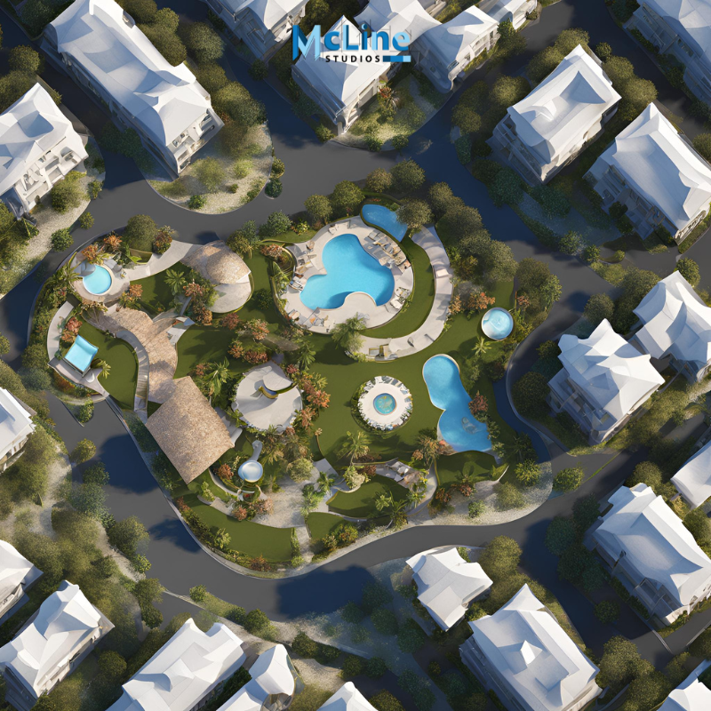
Aerial 3D rendering is a digital visualization technique that creates three-dimensional images or animations from an elevated or bird’s-eye view of a building or landscape. This type of rendering is commonly used in architecture, urban planning, real estate, and construction to give a clear perspective of a design’s surroundings.
By using 3D modeling software, aerial renderings simulate what a building, structure, or area will look like from above. The result is a detailed, realistic image that shows the full scope of a project. These renderings help designers, architects, and clients understand how a property fits into its environment, considering factors like nearby roads, parks, or neighboring buildings.
One of the main advantages of aerial 3D rendering is that it offers a broader view compared to traditional renderings. Instead of just showcasing a single structure, this perspective allows for a clear understanding of the entire layout, making it easier to assess how various elements of a project interact with each other. Whether for marketing materials, project approvals, or design feedback, aerial renderings provide a comprehensive visual tool.
These renderings are especially valuable for large-scale projects like urban developments or residential communities, where understanding the relationship between multiple buildings or outdoor spaces is crucial. Aerial 3D rendering enhances communication, reduces misunderstandings, and ensures better decision-making throughout the project’s life cycle.
Aerial 3D Rendering for Disaster Preparedness
Aerial 3D rendering is becoming an important tool for disaster preparedness. It uses advanced technology to create 3D models of areas from an aerial view, giving planners and emergency responders a clear picture of the landscape. These models can include buildings, roads, trees, and other important features, helping teams understand the environment better.
In disaster preparedness, aerial 3D renderings offer several advantages. First, they allow for detailed mapping of high-risk areas, such as flood zones, earthquake-prone regions, or areas prone to wildfires. With these 3D models, planners can identify the most vulnerable spots and create better evacuation routes or shelter plans. They also help assess the location of essential services like hospitals, fire stations, and emergency response centers, ensuring they are easily accessible during a crisis.
Moreover, aerial 3D renderings can be updated regularly to reflect any changes in the landscape, ensuring that responders have the most accurate data available when a disaster strikes. These models also help in training emergency teams, as they can simulate various disaster scenarios to test different response strategies.
In short, aerial 3D rendering is an invaluable tool for disaster preparedness, as it helps plan, train, and respond more effectively. By providing a clearer view of the affected areas, it improves safety and efficiency when handling emergencies.
Enhancing Disaster Response with Aerial 3D Renderings
Aerial 3D renderings have become a vital tool in improving disaster response efforts. These detailed, bird’s-eye view images provide emergency responders with an accurate representation of affected areas. By using drones and satellites, these renderings capture real-time data. This provides a clear understanding of the damage caused by natural disasters, such as hurricanes, floods, or earthquakes.
One of the biggest advantages of using aerial 3D renderings is the ability to assess disaster zones quickly. Traditional damage assessment methods can be time-consuming. However, 3D renderings allow responders to immediately see the extent of destruction. This helps prioritize efforts and allocate resources more efficiently.
These renderings offer a comprehensive view, highlighting blocked roads, damaged infrastructure, and difficult-to-access areas. They can also be integrated with Geographic Information Systems (GIS) to track changes over time, helping to monitor recovery progress.
Aerial 3D renderings also improve communication between different response teams and agencies. With clear visual data, everyone involved can easily understand the situation and collaborate more effectively, speeding up the recovery process.
In short, aerial 3D renderings are transforming disaster response by offering real-time, accurate, and detailed insights that help save time, resources, and lives. They play a critical role in disaster management, making it easier to respond quickly and effectively.
Key Benefits of Using Aerial 3D Rendering in Emergency Situations
Aerial 3D rendering has become an essential tool in emergencies, offering several key benefits that can save lives and streamline response efforts.
One of the main advantages is the ability to provide a clear, bird’s-eye view of the situation. Emergency responders can get an accurate, real-time visualization of the affected area, which helps them plan their actions more effectively. This is especially useful in large-scale emergencies like natural disasters or fires, where ground access might be difficult or unsafe.
Aerial 3D rendering also allows for rapid assessment of damage. By creating detailed, accurate models, responders can quickly identify hazards and locate survivors. They can also assess the structural integrity of buildings or infrastructure. This can speed up rescue and recovery efforts, potentially saving more lives.
Additionally, these 3D models can be shared instantly with other teams, officials, or organizations involved in the response. This improves communication and ensures that everyone has the same information, leading to better coordination and faster decision-making.
Another important benefit is the ability to monitor the situation over time. Aerial 3D rendering can be updated as the situation evolves. This allows teams to track progress, plan for future actions, and make adjustments as needed.
Overall, aerial 3D rendering helps responders make informed decisions quickly, leading to more efficient and effective emergency response efforts.
The End Note
Aerial 3D rendering is revolutionizing emergency planning and disaster response. It provides real-time, detailed visualizations that enhance situational awareness. This technology improves coordination and optimizes resource allocation.
For disaster preparedness or immediate response, it helps emergency responders and planners assess damage. They can plan evacuation routes and ensure effective resource deployment.
The ability to quickly evaluate affected areas from a bird’s-eye view makes a significant difference. It helps save lives and accelerates recovery efforts.
As this technology evolves, its role in disaster management will grow, enabling faster responses and better community preparedness.


Leave a Reply